The ATES Scale - Simple Terrain - Part 1 of 3
A Simple Tool for a complex environment
The ATES Scale helps you keep decisions simple when the avy-hazard is high
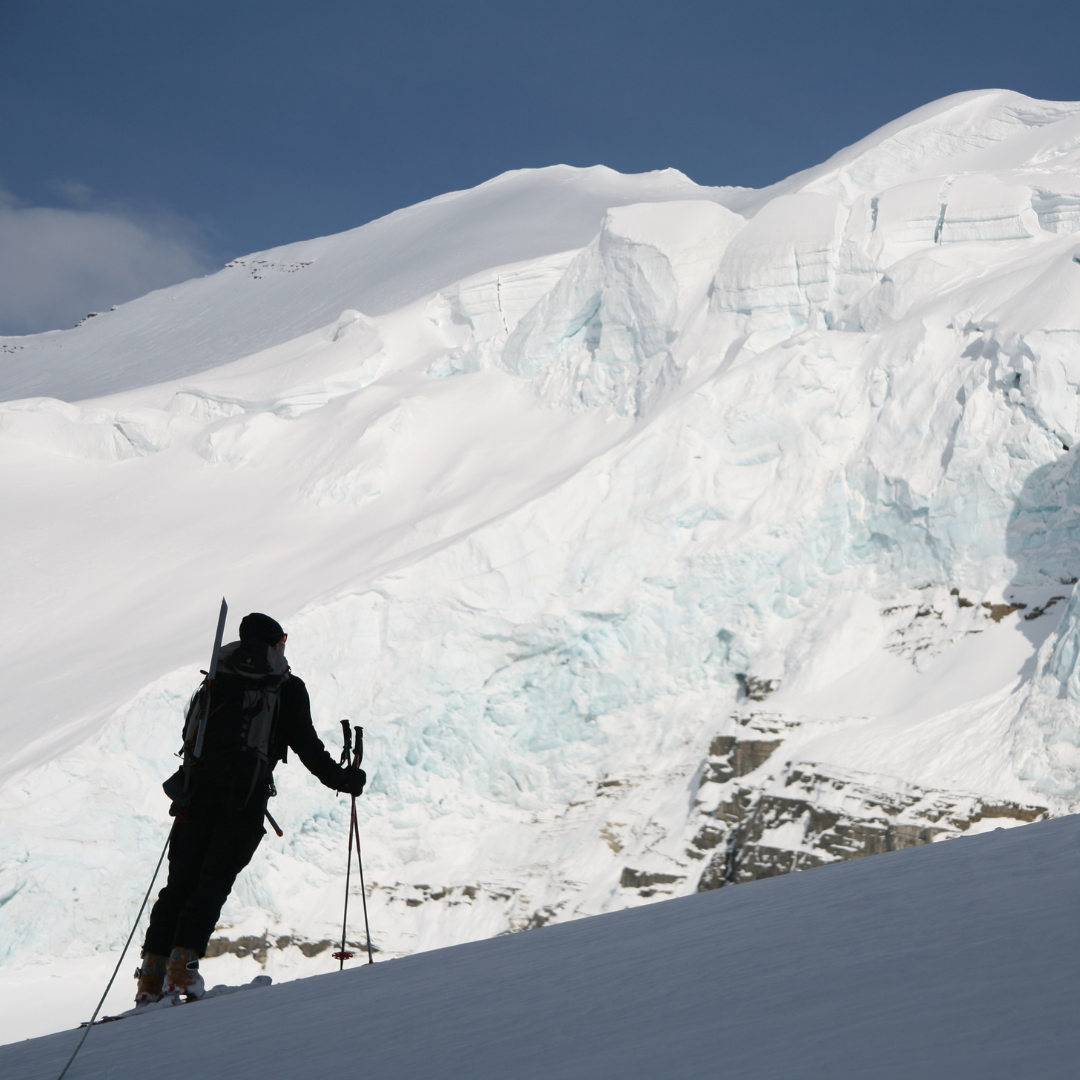
Mountain Bureau LLC AIARE 1 Student in the Cascade WA Backcountry studying the complexity of the terrain before travel. Using the ATES scale a traveler can compartmentalize the terrain relative to the hazard as a tool for making decisions in and around avalanche terrain. -Photo Mark Allen
Even after having all the courses and knowledge on how avalanches form and then trigger, why does it still feel like it is a coin toss.
“Will that slope trigger if I ski it?”.
That’s because in reality the decision is never black and white. It is rather a gradation of probability with respect to the hazard and terrain. This is why even the most skilled avalanche forecaster, who relentlessly studies atmospheric events still will only speak in terms of likelihood. They just can’t tell you with 100% certainty if a slope will slide or not. I have learned to give nature a margin and let it be just that, nature. We can’t possibly understand every nuance of the snowpack to have 100% certainty. There will always be risk of an avalanche in avalanche country. Thankfully there is a tool that many use to manage all these pieces of information, the Avalanche Terrain Exposure Scale or A.T.E.S (ATES). This scale breaks terrain into three easy digestible categories.
SIMPLE
CHALLENGING
COMPLEX
This article will introduce the scale and digest SIMPLE terrain. A major take home is most new and intermediate travelers should be focusing on SIMPLE terrain as your vulnerability of being caught in an avalanche rises significantly when traveling in CHALLENGING terrain.
What is A.T.E.S.?
ATES was developed by individuals at Parks Canada and the Canadian Avalanche Center to better translate avalanche hazard to the public and to allow backcountry travelers to select appropriate terrain for the day based on their group experience and risk profile. The ATES scale has become commonly used in NWAC forecasts, local Cascade ski atlases, and is a focal point of Mountain Bureau AIARE avalanche programs.
This scale works in a similar way to the Yosemite Decimal System (Class I-V) for Rock Climbers or the whitewater Class system. The ATES scale (Class I-III) just as the others, is based on the terrain itself, what the actual portion of earth in front of you presents with respect to avalanche hazard and your understanding of it.
“While experts may possess the intuitive skills for evaluating avalanche terrain, these attributes do not exist in novice backcountry users. Novices require straightforward techniques that allow for a rule-based approach – in other words, quantitative tools to help them understand the significance of [the terrain] they are observing.” Statham-McMahon-Tomm
Image credit: AAC http://publications.americanalpineclub.org/
How do I use it?
The ATES Tool is designed for you to make trip planning rules about terrain character with respect your groups confidence and level of experience. The snowpack in juxtaposition to the terrain, is ever evolving and changing through out the days, weeks and months. So in basic terms the ATES tool will help you select terrain characteristics to eliminate, or rather operate isolated to, for any given days avalanche hazard. When using the scale, the tour planner looks through a filter of their confidence of the hazard and knowledge of the terrain. As the confidence in the avalanche forecast and experience with the terrain grows, so does the ability to reach out into more challenging and complex terrain. As confidence and experience becomes less certain, more simple terrain should be utilized.
Keep that in mind, in all mountain terrain there will be smaller slope scale pieces of terrain that fall out of the scope of your groups confidence and should be approached as if they are a class up in the scale. “It is the avalanche terrain evaluation skills which provide the most security during complex decision-making situations.”, states Statham. This is an important distinction, because terrain you have full control over. In fact it’s the only variable you do have any influence. The terrain is your choice and will change as you travel.
AIARE took this concept one step further and created a GROUP CONFIDENCE or UNCERTAINTY filter to apply this terrain tool.
ATES Scale used with respect to GROUP CONFIDENCE or UNCERTAINTY
When hazard increases - Choose simpler terrain
When terrain is unfamiliar -Choose simpler terrain
When the groups ability is mixed - Choose simpler terrain
When your understanding of the avalanche problem is uncertain - Choose simpler terrain
Consider traveling with an expert or professional capable of managing CHALLENGING and COMPLEX terrain
Factors that play into GROUP CONFIDENCE and UNCERTAINTY are:
Experience and intimate knowledge with the terrain
Experience with the specific avalanche problems stated in the forecast
Confidence in your understanding of the avalanche problems and their distribution in the landscape
Visibility or foul weather
Considerable or higher avalanche hazards
So what are some characteristics SIMPLE TERRAIN ?
Now that we know how the ATES tool works, lets talk about the different types of terrain, starting with SIMPLE terrain. Simple Terrain is great terrain to spend time in as you branch out on your own after having spent time in a Intro to Backcountry Skiing Course and AAIRE 1 Avalanche program. SIMPLE terrain is also a go to when you are new to an area or are traveling to an area you know well but are not up to speed on the seasonal avalanche conditions. It’s also great terrain for storm skiing or shoeing. Specifically, SIMPLE terrain is:
Low slope angle (30 degrees or less)
Primarily in tree line with occasional openings
Multiple route options
Limited exposure to run-outs of large paths
Some but limited exposure to terrain traps and slope convexities
Non-glaciated slopes

Excellent terrain choice keeping it Simple for a higher hazard day. -Photo Nate Disser
Park’s Canada states, “Simple (Class 1) terrain requires common sense, proper equipment, first aid skills, and the discipline to respect avalanche warnings. Simple terrain is usually low avalanche risk, ideal for novices gaining backcountry experience. These trips may not be entirely free from avalanche hazards, and on days when the Backcountry Avalanche Advisory is rated [‘HIGH'], you may want to re-think any backcountry travel that has exposure to avalanches – stick to groomed x-country trails, or within the boundaries of a ski resort”.
In our next blog posts we will introduce CHALLENGING (Class II) and COMPLEX (Class III), stay tuned!
To start learning more, we recommend an AIARE 1 course. The Mountain Bureau AIARE 1 course is for ANYONE, regardless of method of travel as a climber or a skier, who wants to recreate in or near avalanche terrain. Participants may have attended some awareness classes or workshops or completed the Avalanche Rescue course, but none are a prerequisite for this course. Aspiring professionals will need to take the AIARE 1 course and Avalanche Rescue Course as a prerequisite for the Pro 1 course. If you are looking for the next step without going to the Pro level, consider our AIARE 2 Course.
Resources
Complex Terrain on a bluebird day. Does the this add up when looking through the filter of your confidence, understanding of the snow pack, and forecasted hazard has for this day. Despite the pull of the weather does this terrain line up with the Group Confidence?
